Sign of old Cork to be restored and preserved

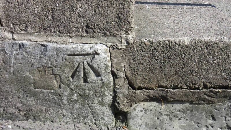
A small piece of Old Cork that had been thought lost to construction works on MacCurtain street and at the bottom of Patrick’s Hill, will now be restored and incorporated into the new public realms.

A small piece of Old Cork that had been thought lost to construction works on MacCurtain street and at the bottom of Patrick’s Hill, will now be restored and incorporated into the new public realms.
A SMALL piece of old Cork that had been thought lost to construction works on MacCurtain street and at the bottom of Patrick’s Hill, will now be restored and incorporated into the new public realms.
Tony McGrath runs a website dedicated to local Cork heritage and lore called readingthesigns where his passion for the quirky details of the city’s streetscapes shines through.
Tony took photographs at the bottom of Patrick’s Hill when he saw the eastern side of the hill barricaded off. He noticed the builder putting a barricade around what are called ‘benchmarks’ etched into the kerbs, and began to fear for these treasured artifacts of the city’s heritage.
“I did fear for the fate of the benchmark,” he said.
Benchmarks resemble a crow’s foot design with a horizontal line on top, and were carved into stones, pillars, corners and buildings, which 19th century engineers used as a surveying guide. They are dotted around Cork and date from the time when Ireland was the first country in the world to be comprehensively mapped.
“Benchmarks as a useful piece of data have long been replaced by GPS,” noted Tony.
“As a mark on the fabric of the city recording how things were done in the past, they are a mark of history. I particularly liked this one as it was in the kerb on St Patrick’s Hill. I have seen many on stone pillars, less in brickwork, on a kerb is very rare.
They represented a reference level for construction.
“How far above sea level are you? This will tell you,” he said.
Lord Mayor Councillor Kieran McCarthy sent a query to the chief road engineer on the project seeking the plan for the marked stone. The response was: “It is not possible to retain the benchmark in its current location; it is to be incorporated into the new public realm enhancements in the vicinity.”
During the Victorian era, the British decided they needed to improve their mapping, primarily related to raising taxes.
“They decided to start with Ireland,” said Tony.
“They thought they’d map Ireland in five years. It took something like 15 to 17 years. When we became a Free State in 1922, we were the best mapped country in the world.”
The benchmarks are a remnant of that system.
Keep up-to-date with the top stories in Cork with our daily newsletter straight to your inbox.
Please click here for our privacy statement.
Have you downloaded your FREE  App?
App?

It's all about Cork!
Add Echolive.ie to your home screen - easy access to Cork news, views, sport and more