Public realm improvements and open space a 'defining feature' in plans to transform Cork docklands

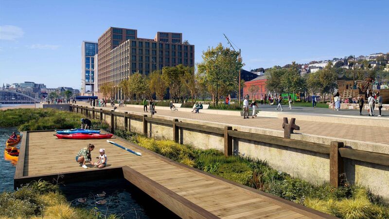
Consultation on Cork Docklands Framework Plan has been launched. Image shows a conceptual view of the North Quays public realm proposal. Image via Cork City Council
Cork City Council published the Cork Docklands Framework Plan for public consultation at the end of April, and consultation remains open until 5pm on Wednesday, May 28.
The regeneration of the 147 hectare brownfield site will create capacity to accommodate approximately 20% of Cork city’s forecasted population growth to 2040 and up to 25,000 jobs, but a huge part of the detailed plans, which can be viewed at the city council website, is community infrastructure, including new sporting and creative activities and extensive public realm on the waterfront site.
Based on a population projection of around 25,000, the plans identify about 9,500sq m of ‘community space’ across the docklands.
They allow for three zoned school sites, significant parks and sports infrastructure, and 5km of quayside public realm.
This will include infrastructure such as libraries, primary healthcare facilities, crèches and childcare, other educational uses, council services, youth centres, creative studios, and after-school clubs.
Three sites zoned for educational use will be developed by the Department of Education in response to demand following the anticipated population growth within Cork Docklands.
A key ambition for the development of these school sites is for them to act as ‘community clusters’ — catering not just to the schoolchildren, but to their families and the neighbourhood community as a whole.
Cork City Council’s City Librarian has advised that approximately 2,000sq m of shared library and community space is required, to be located within the district centre and close to public transport.
Primary healthcare facilities co-located with gardens, well-landscaped outdoor space, and active recreational infrastructure are also included in the plans.
The public realm and open space strategy will be “a defining feature of character” across the city docks, the new variation of the development plan says.
The design will place emphasis on the protection of heritage assets and biodiversity, with the retention and repairing of the historic quay walls, and an integration of both tree planting and sustainable drainage systems into the street design — the designs have been heavily influenced by natural ways to manage flooding on the quayside site.
Focal points for interaction
The council aim to provide focal points for social interaction for people who live and work in the area, or who want to visit, and also create ease of access from one part of the new development to another via a network of pedestrian and cycle routes.
On the south quays, this will involve the creation of a two-tier public realm, operating at two levels, usually one at street level and one either elevated or subterranean.
The new variation on the city development plan promises “quayside amenity areas which will see the transformation of the north and south city quays into a significant new waterfront public amenity space”.
New spaces include Marina Park, a large park to serve not just the immediate area, but the whole city, which is set to be delivered in advance of residential development.
The Shipyard Plaza, an open, public space with a focus on the heritage of the harbour, will include new maritime activities with the patent slip (the mechanical structure used to haul ships out of the water for maintenance, repair, or construction) as the focal point, with places to sit and a wayfinding system or set of signs to help people navigate through the area.
There will also be two linear parks, meaning long and narrow parks along the docks.
Kennedy Spine will extend from Kennedy Park to Kennedy Quay and also on Horgan’s Quay to the north of the River Lee, while Canal Walk will combine a network of swales (channels designed to manage rainwater run-off by slowing it down, filtering it, and allowing it to soak into the ground) with open space and landscape.
Another new park set to be created to work alongside the flood defences is the Polder Cut Park, a wild landscaped park under the overhead ESB electricity power lines.
A polder cut typically refers to a deliberate breach or opening in a flood defence system, used to allow water into a polder area for flood management or ecological purposes.
The public realm design will promote interaction with the water and opportunities for riverside activity.
The design of pontoons will provide public access to the water for small crafts such as kayaks, canoes, currachs, or paddle boards and berthing for leisure crafts.
Sports facility
A new sports and leisure facility, Canal Walk Sports Centre, will be centrally located within the docklands.
The multi-sport campus will accommodate a range of sports that responds to existing active recreation infrastructure deficits within Cork city.
Facilities in the new centre may include a 50m swimming pool, and 25m juvenile swimming pool, with the swimming facilities suitable for high performance athletes, a rehabilitation toning suite and sports injury healthcare spaces, and a soft play or adventure climb facility.
A full-size all-weather, floodlit playing field, usable for casual five-a-side and seven-a-side soccer, as well as a multi-use junior pitch with direct access from an adjacent school site are also included in the plans.
A proposed Maritime Activity Centre to be located at the eastern end of Marina Park will accommodate a range of local maritime activity-based organisations and services, and support and promote collaboration between these groups and organisations to deliver enhanced facilities and amenities.
It will also provide ease of entry to the River Lee through the development of an adjacent public slipway, which will be accessible to all, to encourage participation in water-based activities for Cork citizens and visitors to the city.
Active travel
A key objective is for walking and other forms of active travel to be the main way of getting around the docklands.
There will be an 18-metre wide active travel route called the Blue Green Route through the docklands, extending from Blackrock Road to a new active travel bridge at the quays.
It will see indigenous trees, shrubs, and wildflowers contribute to the aesthetics and also provide wildlife habitats.
Lighting will be designed to consider adjacent residential developments and ecology.
Lord Mayor of Cork councillor Dan Boyle said of the plans: “There have been many plans and conversations over the years regarding the regeneration of Cork Docklands and it is exciting to be at a point where the delivery is becoming reality.
“With the newly upgraded Marina Promenade and the final phase of Marina Park moving towards completion, the required public infrastructure is visibly developing, and this plan can deliver an equally exciting world class urban living district.”
Cork City Council chief executive Valerie O’Sullivan, added: “The Framework Plan is about implementation and the actual delivery of key enabling infrastructure that will further unlock the Docklands opportunity for Cork and for Ireland.
“Cork City Council is committed to ensuring that both the public realm and private development is delivered at a standard and quality that realises our ambition to create a new world class location in which people want to live, work, invest, visit, and explore.”


 App?
App?


