A glimpse back at history of Cork’s bridges

Next week Cork's new bridge, the Mary Elmes bridge, will be pulled up river by barge and lifted into place. The pedestrian and cycle lane bridge, which will connect Patricks Quay and Merchants Quay will be used by 11,000 people every day. Ahead of the significant event, here Cllr Kieran McCarthy reflects on the history of some of Cork's bridges.

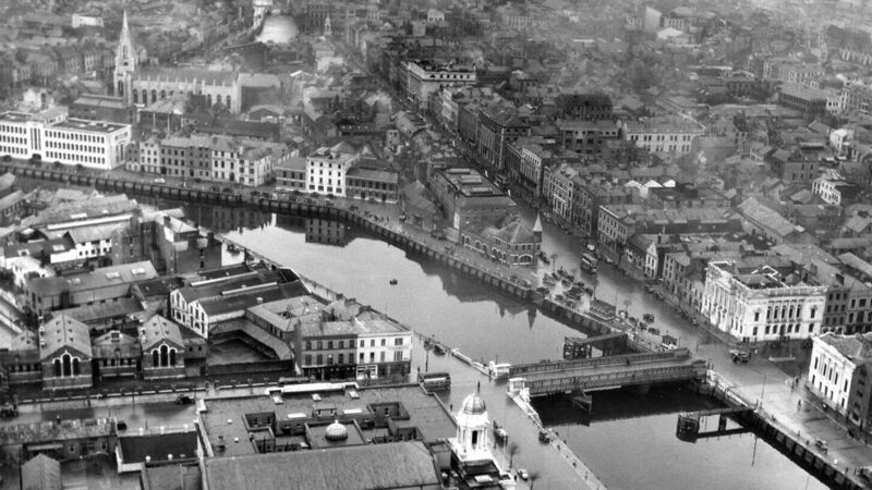
Cork City’s growth on a swamp is an amazing story. The city is constructed on a shift-shaping landscape – sand and gravel, rushes and reeds – a wetland knitted together to create a working port through the ages. Initially it was called Corcach Mór na Mumhan or the Great Marsh of Munster. There is a huge depth to this city’s development. The city possesses a unique character derived from a combination of its plan, topography, built fabric and its location on the lowest crossing point of the river Lee as it meets the tidal estuary and the second largest natural harbour in the world.

Indeed, it is also a city that is unique among other cities, it is the only one which has experienced all phases of Irish urban development, from circa 600 AD to the present day. Hence its bridges all date to different times of growth and possess different architectural traits. Indeed, one would need numerous pages of The Echo to tell all their stories. Truth being told my favourite ones are the earliest ones.

I have always been captivated by the image of a series of planks of wood and a timber structures, which gave access to and across the series of twelfth century late Viking Age houses on what is now South Main Street – but back a thousand years ago was a marshy island complete with streams, mud and tidal problems.

The publication Archaeological Excavations at South Main Street 2003-2005 (2014) records Hiberno Norse or Late Viking structures found under the street. On trowelling back the earth, two to three metres underneath our present day city, archaeologists exposed the remains of timber structures lingering, intrusive and protruding through the mud. There is an indication from the dendrochronological dates of the timbers found on the site that there was a continuous felling of trees and construction of buildings and reclamation structures from just a few years before 1100AD to 1160AD.

By the early 1170s the Anglo-Normans had taken control of large tracts of land from Waterford to Dublin. In 1172 they turned their attention to Cork. Cork was to become one of 56 early Anglo-Norman walled towns established in Ireland, some re-founded on adapted and extended Viking settlements sites.

The name of the town was shortened to Corke. Between the 1170s and 1300s, a stone wall, on average eight metres high, became the new perimeter fence for the old Viking settlement area on the island, which was accessible via a new drawbridge built on the site of the Viking bridge, Droichet. Beyond this wall, a suburb called Dungarvan (now the area of North Main Street) was established on a nearby island.

By 1317 the full circuit of the town walls, which included the extension of the wall around Dungarvan, was complete. Thus, the redevelopment of the town walls created one single walled settlement (16 acres in extent) instead of a walled island with an unfortified island settlement and Dungarvan outside it.

Within the town a channel of water was left between the old walled settlement and the newly encompassed area of Dungarvan, with access between the two provided by an arched stone bridge called Middle Bridge (more or less the site where Castle Street meets North Main Street today). A millrace dominated the western half of this channel (now Liberty Street), while the remaining eastern section was the town’s central dock (part of what is now Castle Street).

The first drawbridge, allowing access from the southern valleyside, was South Gate Drawbridge, while entry from the northern valleyside was via North Gate Drawbridge. From 1300 to 1690 these were the only two bridges spanning the River Lee. There are still bridges on their sites today and they still possess the names North and South Gate Bridge. The present South Gate Bridge dates to 1713 while the present North Gate Bridge dates to 1961.

For nearly five hundred years (c.1200-c.1690), the walled port town of Cork, built in a swamp and at the lowest crossing point of the River Lee and the tidal area, remained as one of the most fortified and vibrant walled settlements in the expanding British colonial empire.
However, economic growth as well as political events in late 17th century Ireland, culminating in the Williamite Siege of Cork in 1690, provided the catalyst for large-scale change within the urban area. The walls were allowed to decay, and this was to inadvertently alter much of the city’s physical, social and economic character in the ensuing century.

By 1800, the walls of Cork were just a memory- the medieval plan was now a small part in something larger – larger in terms of population from 20,000 (in 1700) to 73,000 (in 1759) plus in terms of a new townscape. A new urban text emerged with new bridges such as St Patrick’s Bridge and Clarkes Bridge, streets, quays, residences and warehouses built to intertwine with the natural riverine landscape.

The foundations of the framework of the present-day city centre was formed with bridges such as Parliament Bridge, Anglesea Bridge (a previous Parnell Bridge) and St Vincent’s Bridge providing access from the southern and northern banks of the River Lee to the developing city.
For more information on Cork’s history, check out Kieran’s blog at www.corkheritage.ie.


