Rain warning comes into effect in Cork as forecasters warn of flood risk

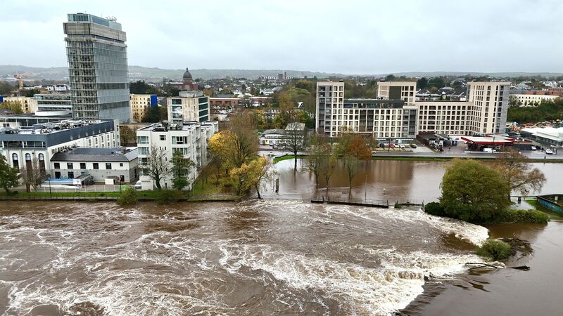
The River Lee in flood at The Lee Fields, Carrigrohane Road, Cork. Picture: Larry Cummins.
A status yellow rain warning for Cork came into effect at 9am this morning and will remain in place for the next 24 hours, with a heightened flood risk for Cork.
Much of the Southern half of the country has had a rain warning issued by Met Éireann, who have warned of heavy and persistent rain falling on saturated ground, possibly leading to flooding, difficult travelling conditions and poor visibility.
Cork County Council has activated a Level 1 flood response plan for East Cork following Met Éireann’s announcement of a “heightened risk” for flooding across Cork this weekend.
Further spells of heavy rainfall are expected over the coming days on already saturated ground, which may lead to excess surface water and further flooding across Cork.
‼️🟠Rain⚠️Dublin Wexford Wicklow
— Met Éireann (@MetEireann) November 14, 2025
12:00 Fri - 08:00 Sat
🟡Rain⚠️Cork Kerry Limerick Tipperary Waterford Carlow Dublin Kildare Kilkenny Louth Meath Wexford Wicklow
09:00 Fri - 09:00 Sat
🟡Wind⚠️Dublin Louth Wexford Wicklow Meath
12:00 Fri - 04:00 Sat
ℹ️https://t.co/w5QtJ1V6un pic.twitter.com/EVI4l2EwlS
A spokesperson for Cork County Council said that crews have inspected known risk locations in East Cork and will continue to monitor and respond as required, and that pumping arrangements have been put in place at locations prone to flooding.
County council crews were out this morning and informed people that the Road N-72-380 though Castlelands and Mallow is now passable again.
Maximum catchment-average accumulations of 30 to 50 mm in 24 hours are expected widely across Munster on Friday and Saturday, with up to 60 mm possible in upland and mountainous areas.
Catchments in southern and eastern regions, particularly those in upland terrain, are likely to respond rapidly to this rainfall, increasing the potential for rivers to rise out of bank and for flooding in flood-prone areas.
Given the already elevated soil moisture and high river baseflows, even moderate additional rainfall may exacerbate existing flooding and prolong elevated river levels. Close monitoring of river gauges and local conditions is strongly advised, especially in areas where ground saturation and drainage capacity are limited.
A weather front associated with Storm Claudia, named earlier this week by the Spanish meteorological service, is forecast to travel north over southern and eastern parts of Ireland. The system will bring prolonged heavy rainfall to Cork and other parts of Munster and Leinster, with the rain expected to 'pack up' against high ground in eastern coastal areas due to northeasterly winds.
Meteorologist Liz Walsh, from Met Éireann, said: “It's going to rain a lot over parts of Leinster and Munster... while it'll stay largely dry for many parts of Connacht and Ulster.
“This rain is brought to us by a weather front derived from Storm Claudia, named earlier in the week by the Spanish met service, and it will fall on already saturated ground and swollen rivers, intensifying the likelihood of significant flooding across Leinster and Munster.
“Coupled with the rain, the northeasterly direction of the wind is expected to bring compound impacts in eastern coastal counties, allowing the rain to essentially 'pack up' against the high ground in these counties.”


 App?
App?


